A Joint Digital Workshop: Reviewing Urban Developments in two Omani Neighbourhoods - part 1
 |
| Image Source - Adapted from diagram by Maryam ZY, with data from ArcGIS |
Guest Author: Shalakha Sara Reji
Shalakha is an Architect from India, and is currently pursuing her Master's degree in 'Integrated Urbanism and Sustainable Design' from the University of Stuttgart, Germany. Her areas of interest include participatory planning methodologies, research on experimental and sustainable urban planning, equitable public space design and so on.
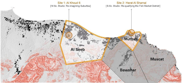
This blog post is part 1 of a 2 part post. It recounts the proceedings of a student workshop conducted – jointly by the University of Stuttgart (Germany) and the Sultan Qaboos University (Oman) – during the months of October and November 2021. The digital workshop was part of the former’s semester project titled ‘Muscat Studio’, and considered within its scope two neighbourhoods: (1) Al Khoud 6 in Al Seeb (covered in this post) and (2) Harat Al Shamal in Muttrah (to be covered in a part 2) as study areas for its M.Sc. and B.Sc. design studios respectively. MCTSpaceLab was involved in the same in an advisory capacity.
On 23rd October 2021, the joint workshop between students of the University of Stuttgart (Germany) and the Sultan Qaboos University (Oman) commenced digitally with a brief round of introductions and a short ice-breaking activity. The participants – who included technical experts, course tutors, undergraduate and postgraduate architecture/urban design students from the two universities – introduced themselves and shared inputs and images, representing their notions regarding urban developments in the Middle East (for students from the German side) or Europe (for their Omani counterparts). This activity continued, via an online concept board, onto a brief mapping of the identified aspects and linked them under certain broad themes, namely socio-economic/cultural, ecological or spatial.
The students were grouped into teams to discuss further the thematic areas. A total of six groups: three from the M.Sc. studio, focusing on the rapidly-growing residential neighbourhood of Al Khoud 6 in Al Seeb, and another three from the B.Sc studio, looking into the historic coastal town of Harat Al Shamal in Muttrah. Each group also comprised at least three students from the Sultan Qaboos University, who would support their peers from Stuttgart in accessing local knowledge and establishing connections with users from the Omani context. In overall, the intended results of this exchange were thus twofold: developing a working relationship among the students of both the universities, and further, carrying out preliminary analyses of the two sites with due consideration for certain specific themes.
After setting up a framework for the workshop as mentioned above, the next steps included expert lectures on various topics such as ‘Muscat’s urban development’ (by Dr. Sonja Nebel), and ‘basics of urban design’ (by Dr. Islam Sallam) on the 23rd, followed by Dr. Naima Benkari’s presentation on ‘housing and heritage in Oman’ on the 28th, and also a lecture by Dr. Josefine Fokdal and Dr. Sigrid Busch on the topic of ‘resilience, sustainable development and urban regeneration in the European context’ on the 30th. Once a general overview of the study context was garnered through these sessions and related discussions, the workshop moved into its next phase, viz. specific inputs for the two selected sites. This began – on the forenoon of 30th October – with site presentations of Al Khoud 6 and Harat Al Shamal by MCTspaceLab’s Rowa Elzain and Rumana Al Othmani. These inputs were supplemented by digital walkthrough videos of the two sites, with the support of experiential narratives from Shaharin Elham Annisa and Mariam Al Taie. Aside from compensating for the absence of a field visit (due to pandemic-related travel restrictions), these walkthroughs also served as clear illustrations of the marked contrast between the two study locales: one, an example of modern-day city expansions and the resultant urban sprawl, and the other, a case for disjoint heritage areas in various stages of disregard or even obliteration. In parallel to these organised events, the workshop also facilitated informal discussions among the student groups via chat platforms or online meeting tools, interviews and questionnaires with local on-site users, etc. and concluded, on 11th November, with a final presentation from each of the six groups – the details of which are elaborated, for both the studios, in the next sections.
After setting up a framework for the workshop as mentioned above, the next steps included expert lectures on various topics such as ‘Muscat’s urban development’ (by Dr. Sonja Nebel), and ‘basics of urban design’ (by Dr. Islam Sallam) on the 23rd, followed by Dr. Naima Benkari’s presentation on ‘housing and heritage in Oman’ on the 28th, and also a lecture by Dr. Josefine Fokdal and Dr. Sigrid Busch on the topic of ‘resilience, sustainable development and urban regeneration in the European context’ on the 30th. Once a general overview of the study context was garnered through these sessions and related discussions, the workshop moved into its next phase, viz. specific inputs for the two selected sites. This began – on the forenoon of 30th October – with site presentations of Al Khoud 6 and Harat Al Shamal by MCTspaceLab’s Rowa Elzain and Rumana Al Othmani. These inputs were supplemented by digital walkthrough videos of the two sites, with the support of experiential narratives from Shaharin Elham Annisa and Mariam Al Taie. Aside from compensating for the absence of a field visit (due to pandemic-related travel restrictions), these walkthroughs also served as clear illustrations of the marked contrast between the two study locales: one, an example of modern-day city expansions and the resultant urban sprawl, and the other, a case for disjoint heritage areas in various stages of disregard or even obliteration. In parallel to these organised events, the workshop also facilitated informal discussions among the student groups via chat platforms or online meeting tools, interviews and questionnaires with local on-site users, etc. and concluded, on 11th November, with a final presentation from each of the six groups – the details of which are elaborated, for both the studios, in the next sections.
Al Khoud 6 (M.Sc. Studio): Site Extents and Impressions
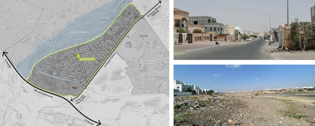
As noted in the previous section, three groups – with thematic focuses as ‘Socio-economic/Cultural’, ‘Environmental/Ecological’ and ‘Spatial’ – were set up, during the initial sessions of the joint workshop, for the M.Sc. design studio under the title ‘Re-Imagining Suburbia’. The site in consideration was the newly-developed neighbourhood of Al Khoud 6 in the Wilayat (Governorate) of Al Seeb, Muscat. The below images show its extent and bounding areas, as well as some photographs that offer a glimpse into its character.
As noted in the previous section, three groups – with thematic focuses as ‘Socio-economic/Cultural’, ‘Environmental/Ecological’ and ‘Spatial’ – were set up, during the initial sessions of the joint workshop, for the M.Sc. design studio under the title ‘Re-Imagining Suburbia’. The site in consideration was the newly-developed neighbourhood of Al Khoud 6 in the Wilayat (Governorate) of Al Seeb, Muscat. The below images show its extent and bounding areas, as well as some photographs that offer a glimpse into its character.
 |
| Image Source - MCTspaceLab 2021 |
Al Khoud 6 is bounded on the west by Wadi Al Khoud, and on its southern and eastern edges, it is abutted by two heavily-trafficked main roads: the Muscat Expressway and the Al Khoud Street respectively. The site demarcated for this study was approximately 5 km² in area, and was set in alignment with the aforesaid boundaries. Through preliminary discussions from the workshop’s initial phases, certain problems were already identified as prevalent within the chosen site – for instance, a tendency for urban sprawl (due to the random system of land allotment and consequently, unoccupied or poorly-maintained plots interspersed with those in active use), issues relating to resource management or the local environment, and challenges concerning public space usage etc. These were then formulated tentatively into sets of research questions for each of the groups, with the objective of arriving at a SWOT analysis (i.e. a matrix of Strengths, Weaknesses, Opportunities, and Threats) for all the three themes.
For the theme of ‘Socio-economic/Cultural’ aspects, the outlined research questions were as follows:
(i) What uses and functions can be found in this area?
(ii) Are there any public/cultural facilities located in and around the district?
(iii) Are there areas or elements that have a special significance for the social and cultural life in this district/in Muscat?
(iv) What is the social structure of this area like?
(v) How fragmented or coherent is the local population?
(vi) Are there signs of community cohesion in this area and, if so, how are they defined?
(vii) Which aspects are important for the life of the people in this community? Which social paradigms and cultural dynamics have shaped this quarter?
(viii) Are there tensions and challenges with regard to the social and cultural development of this area? (ix) What are the expectations/needs of the local population in terms of improving their cultural and social life?
The team carried out a set of interviews and sent out a brief online questionnaire, in addition to secondary research tools such as literature reviews, in order to arrive at suitable responses for the above-stated guiding questions.
Some relevant findings from this group included their categorization of the site’s major users as locals or expats (in a 70:30 ratio), permanent or temporary residents (e.g. renters or university students), as well as by gender, profession and economic status – which was then followed by a rough mapping of these divisions onto a zoning plan. Lastly, based also on studies of Al Khoud 6’s community structure and the spaces of socio-cultural significance therein (e.g. the Hayi Al Maarifa area), the team concluded their analysis with a presentation that highlighted both potentials of the neighbourhood on account of its existing social connections and bottom-up initiatives, as well as anticipated certain issues due to limited diversity or a lack of community cohesion in some regions.
The next thematic group, ‘Environmental/Ecological’ dealt with the following research questions:
(i) What are the ecological challenges in this area?
(ii) What is the situation with regard to heat waves and heavy rain events?
(iii) Is there a need for adaptation/mitigation?
(iv) To what extent do the urban structure and the existing buildings provide an adequate answer to climatic challenges?
(v) Which forms of mobility predominate?
(vi) How could sustainable mobility be promoted?
(vii) How are resources (water/energy/waste etc.) handled in the area?
(viii) Are there any noticeable challenges in dealing with resources?
(ix) What are the needs and expectations of the people in this area with regard to an ecological re-qualification of this site?
In order to address the same, the team conducted several digital assessments via GIS-based tools (such as i-Tree Canopy), virtual mapping etc. alongside reviews of theoretical data. Starting from a broad overview of the region’s climatic conditions and natural features, the study was narrowed down to Al Khoud 6 and its immediate locale – through an identification of its various ecological characteristics: such as land cover classes and their distribution, species diversity and ecosystem services (i.e. cultural, supporting, provisioning and regulatory services). Further, the topics of mobility, energy management, resource utilisation and environmental challenges were also discussed in brief, alongside the afore-mentioned subjects.
In overall, this group presented a summary of the site’s ecological context, and derived from the same its strengths (e.g. proximity to the Wadi, high solar incidence as a renewable energy source) and weaknesses (e.g. climatic issues, lack of awareness etc.), to conclude with certain suggestions and a conceptual design, as shown in the image above.
The third team researched the theme ‘Spatial’ aspects by considering the following questions:
(i) What is the characteristic of this morphology?
(ii) What types of building structures prevail in the different parts of this district, and how are they defined?
(iii) What building density and floor heights can be found here?
(iv) Which open space structures can be recognized?
(v) How is the distinction between public and private space defined spatially?
(vi) What is the quality of the building stock and the open spaces?
(vii) Are there historical buildings/facilities/spaces that are important for the identity of the district? (viii) What is the situation of the area like in terms of connectivity with adjacent neighbourhoods/facilities?
(ix) How is the district integrated spatially into the overall structure of Muscat?
This group employed a series of mapping exercises, in conjunction with on-site documentation (collected by the Omani students) and literary data, to answer the above questions. The foremost section of their work illustrated Al Khoud 6’s location in relation to its surrounding context, traced its sequential pattern of growth (from 2008 to the present), and discussed in brief the overall layout and morphological structure of the neighbourhood. This was then complemented by detailed analyses of the area’s built uses and typologies (residential villas/apartments, commercial, governmental and cultural/religious buildings), their specific characteristics (such as appearance, material palette, floor heights etc.) and further, a study of public-private distinction for the identified building types, as well as an overview of the sites’s open space structure. In conclusion, the impacts of these spatial characteristics – both positive (e.g. available spaces for future interventions, scope for re-adjusted sidewalk usage) and negative (e.g. urban sprawl, uneven land distribution) – were reviewed and certain recommendations were then put forth.
Conclusion
Wrapping up the workshop, its last day – the 11th of November – thus began with the final presentations from all three groups, as detailed in the above sections. These were followed by feedback and discussion sessions, which then continued onto the formulation of certain new focal themes: around which the remainder of the semester's work would be centred. For the Masters studio, these groups were identified as ‘Land management and housing’, ‘Mobility and accessibility’, ‘Development of public and open spaces’, ‘Governing suburbia’, and ‘Ecological development’. In overall, the joint workshop can therefore be considered a relevant precursor to many of the further inputs (e.g. tutorials, lectures on ‘consultative democracy’ or ‘urban ecology’ in Muscat/Oman, or insights on upcoming projects such as the Al Mouj community hub etc.) as well as some ongoing projects of the corresponding courses. Lastly, maintaining its tone of intercultural exchange – as set from the start of the workshop – the event drew to an official close in a comparable manner, with an online Omani ‘karak’ tea-making activity - ending on a sweet note and the promise of more such collaborations to come.
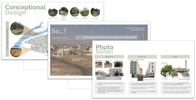 |
| Snippets from Final Presentation: Site Analysis and Design Ideas Image Source - Environmental/Ecological Group |
Wonderful to see such vision applied to reality. I was Landscape Architect in Oman +/- 9 years it was often to see a true future vision except from students and student projects, Mabrouk! Itwould be great to see all materials presented.
ReplyDelete